
Features Dommit
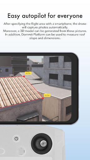
※To use this application, you need to purchase a license on Dommit Platform.Dommit is a user-friendly estimating tool that use a drone to capture aerial images, facilitating accurate evaluations of exterior conditions and dimensional measurements.On construction sites, whether for new construction or renovations, it is common to invest time and resources to determine the current condition of a building, often by climbing dangerous heights on the roof.
However, by utilizing a drone to fly and capture photos of the roof, a general overview of the buildings current status can be obtained without the need for scaffolding or other surveying equipment.
Dommit Drone is designed to fly and take photos automatically, making it easily accessible to those unfamiliar with operating drones.
Additionally, by generating a 3D model from the captured data, on-site dimensional measurements become unnecessary.1.
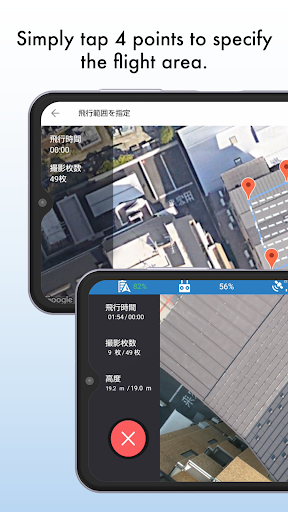
AutopilotThe drones flight range can be specified by simply tapping the four roof points on the map.
Both "hierarchical" and "metric" flight heights can be set.
Takeoff is a one-button process, allowing users of all skill levels to easily operate the drone, regardless of the property size or familiarity with the smartphone operation.2.
Auto-shootingNo drone operation is required after the flight starts.
The number of photoshoots will be automatically determined according to the size of the property, and shooting will be executed automatically.
After the shooting is completed, the drone automatically returns to the departure point.
Manual shooting is also supported, so additional photoshoots can be taken in specific areas by manually operating the drone.3.
Hand-held shootingHand-held shooting can be performed by holding the drone body by hand and pressing the shutter button on the screen.
This is recommended for photographing exterior walls.4.
3D model creationThe photos that were captured automatically are transferred from the smartphone to the Dommit Platform and saved automatically.
By using the photos stored in the Dommit Platform, a 3D model is generated, allowing the calculation of roof dimensions and slope.5.
Project and property managementAccess the details regarding completed projects and properties generated on the Dommit Platform from anywhere, even outside of the office.6.
3D Model ConfirmationThe 3D model generated can be reviewed using Dommit Drone.
Recommended for a quick check after the shooting is finished.7.
Photos ConfirmationThe captured photos can be reviewed using Dommit Drone.
Recommended for a quick check after the shooting is finished.Dommit Official Websitehttps://www.dommit.netPrivacy Policyhttps://www.dommit.net/privacy-policy
Camera Features
Advanced camera features with editing capabilities.
Travel Features
Plan and manage your travels with ease.
Food & Dining
Discover recipes and order food from your favorite restaurants.
See the Dommit in Action
Get the App Today
Available for Android 8.0 and above